Alternate Earthen Final Cover: Kansas Landfill
Kansas
Location
Kyle Kukuk
Contact
Service Lines
Project Summary
Blackstone recently completed an annual vegetation survey for an Alternative Earthen Final Cover (AEFC) at a Kansas landfill. The AEFC design includes native grasses, wildflowers (forbs), and trees. The goal of the AEFC is to produce a final cover that provides a more naturally sustainable, ecosystem-based design requiring less maintenance and providing improved structural integrity, water uptake, vegetation health, nutrient recycling, and wildlife/aesthetic characteristics. The AEFC design is intended to encourage/accelerate the re-establishment of a native grassland-woodland community on the landfill after closure of each area.
Services Provided
The annual vegetation survey included the evaluation of overall health of AEFC areas and determination if additional seeding or maintenance was required. Areas planted in native grasses and forbs were surveyed for species diversity, and a tree survival count was conducted in tree planting areas. Areas of significant stands of volunteer trees were identified. Areas were also surveyed for the presence of invasive species such as Johnson Grass and Eastern Red Cedar.
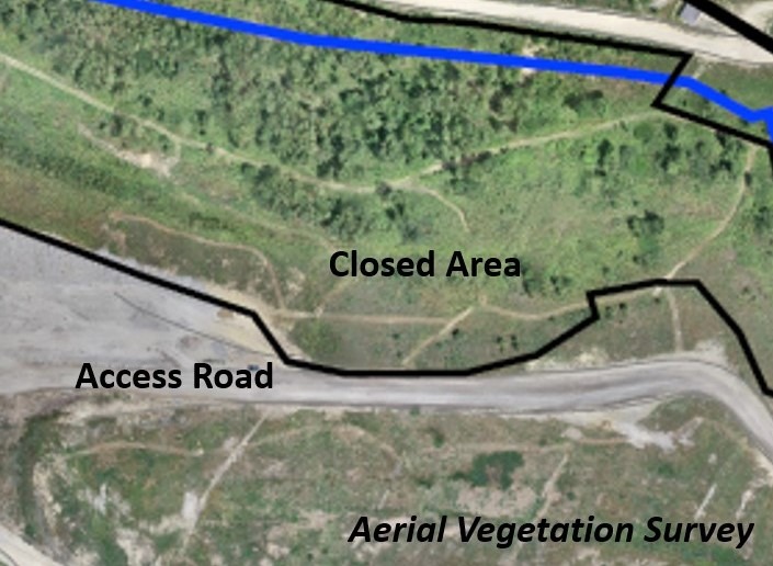
During the survey, Blackstone employed our Unmanned Aerial Vehicle (UAV) to conduct a survey of closed landfill areas. Aerial imagery of the sites provided a visual overview of the AEFC and surrounding area during the growing season. Drone imagery was collected using a standard RGB camera (captures red, green and blue visible wavelengths).
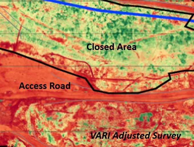
Analysis of this imagery using post-production software provided insights into the relative health of AEFC vegetation. The imagery collected was processed to determine the relative plant health using the Visible Atmospherically Resistant Index (VARI) algorithm. For each pixel VARI calculates a ratio of green vegetation cover. The VARI algorithm is designed and tested to work with RGB sensors as a more useful and accurate way to measure plant health using RGB imagery.
The VARI algorithm uses color correction to minimize reflectance, scattering, and other atmospheric effects to better estimate the fraction of healthy vegetation in an area. It helps show how green a plant is in comparison to others to allow approximation of the relative plant health and vegetation coverage.
Aerial imagery from the drone flight was compared to the relative vegetative health (VARI adjusted) imagery. The healthier and greener areas of the VARI analysis were found within the closed and capped areas of AEFC. The less healthy redder areas were primarily uncapped areas, the active face, and associated haul roads.
Additionally, the UAV survey was used to produce high-resolution topographic contour data for the site. Topographic contour data from previous years were compared to look for signs of reduced vegetation, slope failures, or subsidence.
Performing annual UAV surveys to collect ortho-imagery and VARI analysis in combination with the production of high resolution topographic contour data will provide an intuitive view of the general health and status of the AEFC. The visual assessment of vegetative health will aid in tracking the health and development of AEFC plantings from year to year, as well as allowing for identification of growth trends and patterns over time and detection of areas in need of maintenance, and topographic contour data from previous years can be compared and evaluated to look for signs of reduced vegetation, slope failures, or subsidence.